Imagine you’re a soybean farmer facing a silent threat to your crops. Charcoal rot, caused by a sneaky soil fungus called Macrophomina phaseolina, can wreak havoc on your harvest without warning. But fear not! Scientists have come to the rescue with new risk maps that can predict where this pesky fungus is likely to strike based on the soil conditions below the surface.
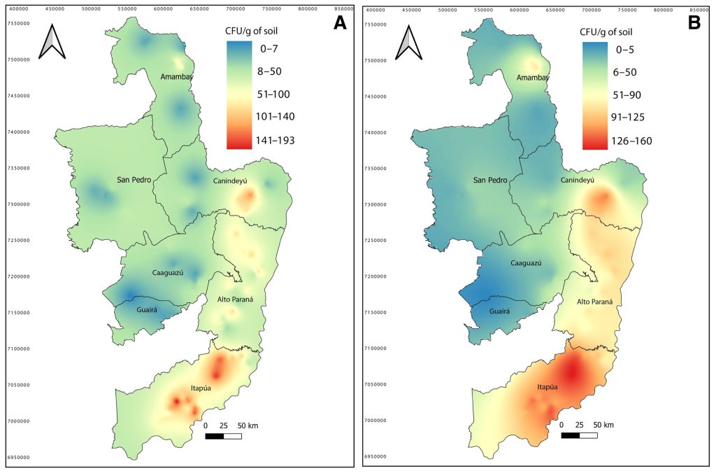
Led by Horacio Lopez-Nicora and Sandip Mondal from The Ohio State University, the research team ventured into 297 soybean fields across Paraguay in South America, a hotspot for soybean production. Their investigation uncovered that the fungus is most abundant in the southeastern part of the country, where the soil is acidic and clay-rich.
By using special mapping techniques and predictive models, these scientists are empowering farmers to anticipate charcoal rot issues before they become a nightmare. Instead of waiting for symptoms to show up, the maps analyze soil properties like pH levels, clay content, and cation exchange capacity to assess the risk of fungal invasion. They discovered that lower pH levels are linked to higher fungal abundance, giving farmers a heads-up on potential trouble spots.
This innovative approach not only identifies vulnerable fields but also pinpoints where the fungus tends to cluster rather than spreading evenly. Traditional scouting methods often miss these patterns, but now farmers have a powerful tool to reveal high-risk areas.
These insights are gold for precision agriculture, offering tailored strategies to manage charcoal rot effectively. Adjusting planting schedules, rotating crops, and applying soil amendments only where needed can save costs and safeguard yields in the face of unpredictable climate changes.
The impact of this research stretches beyond individual growers to policymakers, providing a blueprint for integrating soil data and disease forecasts into national crop protection plans. This groundbreaking study paves the way for a new era of predictive, efficient, and sustainable farming practices that harness the power of spatial data and smart technology.
Collaborating with experts from various institutions, the team sets a new standard for leveraging data and technology to revolutionize crop management. Their work is particularly crucial for regions grappling with extreme weather conditions and pesky soil-borne pathogens, offering hope for a more resilient agricultural future.
If you would like to see similar science posts like this, click here & share this article with your friends!